Thompson Falls
About the Thompson Falls Hydroelectric Facility
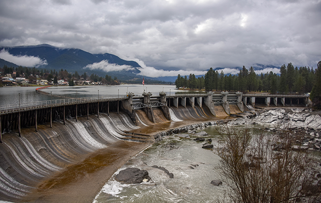
The Vision for Thompson Falls emerged over a century ago, as dreamers and developers grasped the potential of the massive volume of water carried by the Clark Fork River. Located 100 miles northwest of Missoula Montana, this 7-unit hydroelectric unit has a generation capacity of 94 megawatts. Construction of the dam began in 1913 and took 21 months, being completed in 1915.
The amount of water that passes through Thompson Falls is greater than any other dam in the Montana system. With the highest known flow on the Missouri being 126,000 per second at the "Big Falls," during a flood in 1908, and the highest known flow at Thompson Falls being 163,000 per second in 1948.
Historic Namesake
Historic Namesake
The community of Thompson Falls was originally known as "Thompson," and was named for David Thompson, a British-Canadian fur trader, cartographer, and surveyor. Thompson established a fur trading post in the area in 1809 and is credited with mapping more of North America than any other individual.
The town was established in 1882, and "Falls" was added to its name a year later, reflecting the name given to the rail station there by the Northern Pacific Railway.
Thompson Falls Fish Ladder
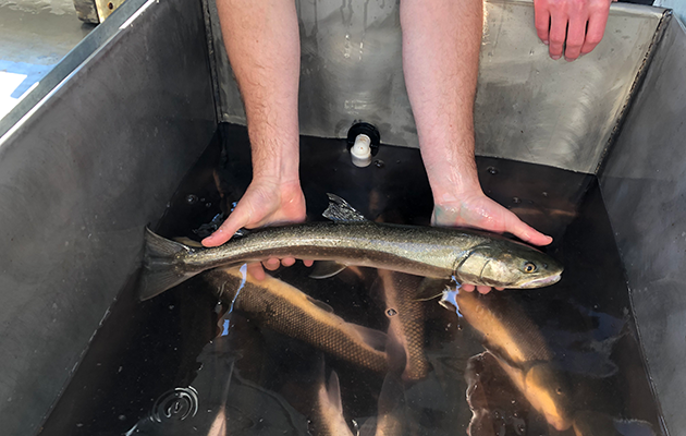
Thompson Falls Fish Ladder
Investment in the Thompson Falls plant has been extensive in the last 50 years. In 1995, a $50 million addition of a new generation unit was put into service, and a full-height fish ladder was added in 2011.
This $10 million investment was put in place to help bull trout reach spawning grounds above the dam. Northwestern Energy pays for biologists to help operate and monitor the fish ladder.
"Golden Kilowatts: Water Power and the Early Growth of Montana"
The book "Golden Kilowatts: Water Power and the Early Growth of Montana" by Butch Larcombe tells the history of Montana's dams.
Historic American Engineering Record (HAER)
The Historic American Engineering Record (HAER) was established in 1969 as one of the Heritage Documentation Programs administered by the National Park Service (NPS) to record the engineering and industrial heritage of the United States. HAER was created through agreements between the NPS, the Library of Congress, and several engineering societies.
HAER documents a variety of engineering and industrial sites, structures and objects. Transportation infrastructure, bridges, mines, industrial buildings/machinery and public utilities are all types of engineering and industrial heritage that have been recorded under this program. The goal of the HAER program is to record the engineering heritage that is subject to being lost due to a variety of factors. These may include technological advancements creating obsolescence, changing regulations surrounding health/environmental/public safety, and development issues. The NPS, through their Heritage Documentation Program, issues the guidelines for HAER documentation and its dissemination.
As part of the FERC licenses for the eleven hydroelectric facilities that NorthWestern Energy own and operate, HAER documentation is conducted when a project or upgrade is determined to have an adverse effect on a facility’s engineering heritage. After the HAER documentation is completed for a particular project or upgrade, NorthWestern Energy submits the documentation to the NPS for review and acceptance. Once accepted, the HAER program coordinates with the Library of Congress to store the document and disseminate it to the public on their website.
Each link below connects to the applicable HAER document available on the Library of Congress website. Visit Historic American Engineering Record (HAER) Documentation to learn more about the HAER documentation conducted at other NorthWestern Energy hydroelectric facilities.
Historic American Engineering Record (HAER) Documentation
Thompson Falls Hydroelectric Facility:
- Thompson Falls Hydroelectric Project, Main Channel Dam, Clark Fork River, Thompson Falls, Sanders County, MT
- Thompson Falls Hydroelectric Project, Warming Hut, On east slope of Main Island, about 35 feet south-southwest of Main Channel Dam, Thompson Falls, Sanders County, MT
- Thompson Falls Hydroelectric Project, Power Foreman's Bungalow, On island between Forebay Channel & ClarkFord River, Thompson Falls, Sanders County, MT
- Thompson Falls Hydroelectric Project, Chicken House, On island between Forebay Channel & ClarkFord River, Thompson Falls, Sanders County, MT
- Thompson Falls Hydroelectric Project, Garage, On road to powerhouse, Thompson Falls, Sanders County, MT